 |
| Low pressure will move across southern Quebec Tuesday with heavy rain forecast. (AccuWeather) |
It was not a terrible weather weekend across southern Quebec, but still far from perfect. There was more sunshine than I expected on Saturday and far more cloud cover on Sunday. Both days featured spectacular starts to the day, but in that unseasonably fall like atmosphere we seem to have lately, clouds and even fog developed by mid-morning and remained in one form or another the rest of the day. Sunday afternoon was the best period, at least here on L'Ile Perrot, as skies cleared and we hit 29C (85F).
 |
| The sunset Saturday night in Vaudreuil resembled a painters canvas. Plenty of moisture in the atmosphere lately has created some very busy skies during the day, with rapid clearing at sunset. (ValleyWeather Photo) |
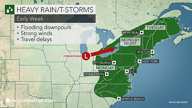
As we start another work week, Montreal can expect a mostly sunny day (fingers crossed), along with warm high temperatures near 28C (83F). Enjoy today because the rest of the week looks rather unsettled and at times dismal. Developing low pressure over the US Midwest will move from Lake Erie down the St. Lawrence Valley on Tuesday. Rain will develop overnight in Montreal and persist all day Tuesday. Amounts will range from 20-30mm along the St. Lawrence Valley to as much as 60mm in the Laurentians and north of Quebec City. Environment Canada has posted heavy rainfall warnings for the region north of the St. Lawrence River. The rain will be accompanied by the occasional rumble of thunder as well as gusty winds. With the rain, temperatures will remain below normal with a low of 18C (65F) tonight but only up to 21C (70F) on Tuesday. The remainder of the week looks unsettled with slightly below normal temperatures and the ever present risk of showers or thunderstorms.

No comments:
Post a Comment