 |
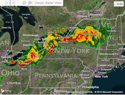
| A radar capture this morning shows the heaviest rain and thunderstorms (deep red and yellow), moving east across southern Ontario and into New York State well south of Montreal and Ottawa. |
Watching the radar trends early this morning, it appears the heaviest rain and strong thunderstorms are moving south of Montreal. It has been a very stormy night in the Great Lakes basin including Toronto. A wide area of heavy rain and thunderstorms has been affecting southern Ontario as far east as Kingston and then south into New York state. The system has produced heavy rain along with flash flooding as well as frequent lightning. It looks like the bulk of the heavy weather associated with this front will remain in New York and Vermont today. There is just an outside chance of a shower or afternoon thunderstorm in Quebec, especially along the US border. The strongest storms with hail and high winds will be focused in southern Vermont and New Hampshire.
Montreal can expect another muggy day before the atmosphere dries out a little on Wednesday. It was very mild overnight, remaining near 20C (68F). The high temperature today will be near 24C (76F). Winds will be gusty up to 60km/h in the St. Lawrence Valley. It will be clear, windy and cool overnight with a low near 13C (55F). Wednesday looks sunny with a slight chance of an afternoon shower and a high near 23C (73F).

No comments:
Post a Comment