 |
| A major storm will impact New England and eastern Canada this week. (AccuWeather) |
Just 24 hours after telling you all things looked quiet for Montreal for the next week, it appears a new east coast storm will edge further westward into southern and eastern Quebec on Tuesday. Let's start with yesterday's storm that completely missed Montreal but left 15-30cm of snow from New Jersey into New Brunswick. As the storm bombed out overnight east of Nova Scotia winds picked up as well gusting to nearly 80km/h in Halifax. Montreal received about 1cm of snow last evening from an arctic cold front, as well as a few hours of freezing drizzle in advance of the front. The temperatures were mild on Saturday in Montreal at 0C (32F) but have since dropped to the current reading here on L'Ile Perrot of -15C (5F). It will be sunny but cold today and Monday with highs near -11C (12F) in Montreal.
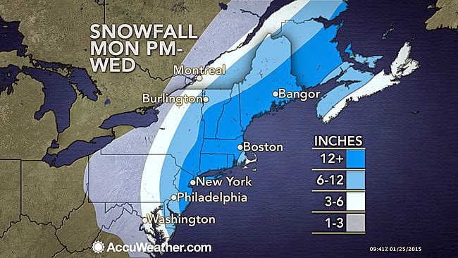 |
| Montreal will remain right on the edge of the precipitation shield with perhaps 5cm of snow on Tuesday. It will be windy and cold. |
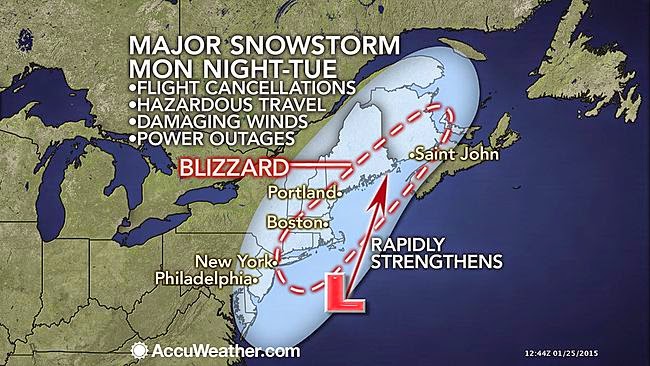
NEW Nor'Easter
A new clipper-type low pressure system will be moving from the Prairies across the Ohio Valley on Monday and off the coast of Virginia by late in the day. It will then strengthen and is forecast to become a powerful Nor'Easter that will make news as it moves towards Nova Scotia by Wednesday. Just 36 hours ago the models had this storm system passing well out to sea. But now it is expected to move much closer to the coast and provide all of New England and eastern Canada with a major storm. Some portions of the coastal regions from New York to Atlantic Canada could see 30-60cm (1-2 feet) of snow. Winds are forecast to howl over 100km/h (60 mph) with the snow on Tuesday causing blizzard conditions in Boston and New York City. High surf may cause coastal flooding for New England and Nova Scotia. This storm will be strengthening as it slowly moves northeast along the coast. Winds are forecast to increase out of the northeast on Tuesday in Montreal (over 50km/h) and the rest of southern Quebec as well. We can now expect some snow on Tuesday, but the bulk of the accumulations will be well south and east of Montreal. I expect perhaps 5cm (2 inches) for Montreal, more for the Townships and Quebec City, but this will have to be watched closely as there remains much uncertainty with the exact track. Travel will be very difficult to impossible in eastern Quebec, New Brunswick, P.E.I, portions of Nova Scotia as well as New England, so if you have plans Tuesday pay close attention to later forecasts. So far in our region, a Winter Storm Watch is in effect for southern Vermont as well as a Special Weather Statement for Atlantic Canada.
No comments:
Post a Comment