It feels more like a mid July morning in southern Quebec than October with temperatures in the high teens and high humidity. Tuesday was a record warm day in Montreal with a high temperature at Trudeau Airport of 24.8C (77F), beating the old record of 22.8C set in 1970. We were part of a bunch of record high temperatures including 28C (84F) at Massena/Cornwall and 26C (79F) at Burlington, Vermont. Burlington also posted another record on Wednesday when the temperature hit 27C (80F), this beat the old record that dated back to the 1930's. Montreal was a very warm 24C (76F) on Wednesday, short of the record of 26C. The warm and humid air is being pushed north by a combination of the slowest moving cold front ever and the broad circulation around high pressure in the Atlantic Ocean and Hurricane Gonzala. An area of very heavy rain is associated with the slow moving frontal system to our west, and that rain will arrive in Montreal today. Look for periods of rain with some thunder lasting into Friday with perhaps as much as 25mm (1 inch) for the St. Lawrence Valley. Temperatures will continue warm with highs near 22C. The normal high for this date is 12C (54F) with the low around 3C (39F), so it is exceptionally warm, especially the overnight lows which have been warmer than the normal highs! We are on borrowed time, it will turn windy and colder this weekend as a strong cold front crosses Quebec and Ontario on Saturday. Temperatures will return to normal values by Sunday, even below average with showers and perhaps some flurries over the highest elevations. Highs will only be near 10C (50F) with lows near 0C (32F) by Monday morning.
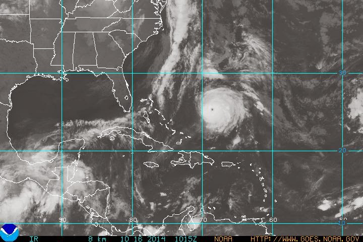 |
| NOAA image showing a well defined and powerful Hurricane Gonzala (middle right) over the Atlantic Ocean. |
HURRICANE GONZALA
Gonzala this morning is a major storm located 540 miles (865km) southwest of Bermuda. The hurricane has 140 mph winds and a central pressure of 945 mb, a Category 4 storm, and one of the strongest Atlantic Basin hurricanes on record for October. Gonzala is moving north at 9 mph, and will come very close to Bermuda on Friday with a large storm surge, up to 150mm (6 inches) of rain and fierce winds. Warnings are in effect, and precautions are being rushed today to protect life and property. Beyond Bermuda it looks like the storm will transition into a strong post tropical storm and affect eastern Nova Scotia and Newfoundland this weekend. Very heavy rain and strong winds are possible, but the forecast details need to be fine tuned. The storm will begin to affect Atlantic Canada by Saturday.
Tomorrow: The 60th Anniversary of Hurricane Hazel was October 15, 2014. I will take a look back at one of the strongest storms to affect Canada tomorrow.
No comments:
Post a Comment