An upper level low spinning its way across eastern Ontario and into northern New York has kept cloud cover and instability largely over that region. On Thursday a few showers did develop in Montreal, but only around 6mm fell here on L'Ile Perrot, with just a trace at Trudeau Airport in Dorval. Temperatures were around 23C (73F) but it felt rather warm and muggy. All in all it was not a bad day, and we are looking at an almost identical forecast for today with just a slight chance of showers. More drenching thunderstorms are possible in eastern Ontario through this afternoon. The good news is strong high pressure will settle south into the St. Lawrence Valley and slowly drift southeast. This will set the stage for a prolonged period of sunny, warm weather from Saturday into the middle of next week. Temperatures will be very warm during the day from 27-29C (80-85F). Overnight lows will range from 12-16C (54-61F) with the chance of fog. Winds will be light.
EASTERN ONTARIO STORMS
Meanwhile some daytime heating interacting with the energy from the low produced a narrow band of very slow moving, drenching thunderstorms from the western Rideau Valley east into Kemptville and the south end of Ottawa. Rainfall amounts were very impressive with 50mm (2 inches) at Kemptville, Ontario but reports of as much as 80mm (3 inches) coming from my fellow weather watcher Jane, who lives west of Kemptville. Radar estimates and ground observations show as much as 130mm in some communities northwest of Smiths Falls and in Lanark County. The bulk of that rain fell in a deluge in a few hours during the middle to late afternoon. Creeks and rivers will respond with elevated flows over the next few days but at this time no major flooding is expected.
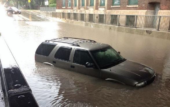 |
| Winnipeg, Manitoba on Thursday after 50-75mm of rain. (TWN Photo) |
Major flooding did occur in Winnipeg yesterday as thunderstorms swept that city dumping as much as 75mm of rain in just a few hours. In what has become a familiar scene this summer in many metro regions across North America, numerous highways flooded trapping motorists. There were widespread reports of basement flooding, power outages and water in one major mall.
No comments:
Post a Comment