The forecast for the most part was dry on Canada Day for Montreal with thunderstorms remaining over the Laurentians and Ottawa Valley or well south of Quebec in central New York. The storms were fast moving but did produce some wind damage across the lower Laurentians. Today's risk for storms is rather low for Montreal with the main dynamic south of the city across New York and Vermont and perhaps into the Sherbrooke area.It will remain hazy and humid in southern Quebec into Thursday with lows tonight near 22C and highs Thursday once again approaching 30C. A trough will bring showers and thunderstorms late Thursday with cooler and dryer weather arriving by late Friday. The weekend looks sunny with near normal temperatures.
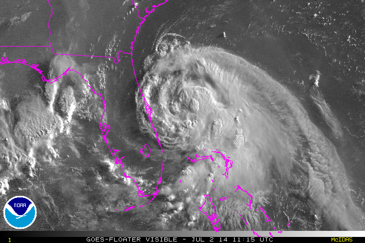 |
| A spectacular visible image of a strengthening tropical storm Arthur east of Florida this morning. Note the thunderstorm tops bubbling high into the atmosphere. (NOAA) |
Tropical storm Arthur developed as expected on Tuesday and now has 60mph winds. The deepening storm with impressive convection is located a few miles off the Florida coast about 495 miles south of Charleston, South Carolina, moving north at 6 mph. This morning tropical storm warnings are in affect along the Florida coast, with a hurricane watch posted along the fragile North Carolina coast including the Outer Banks south of Oregon Inlet. Arthur is forecast to intensify into a minimal hurricane while approaching North Carolina by Friday. Heavy rain and high surf will be the primary threat at this time. I have vacationed on Hatteras Island since 1991 and this region is highly vulnerable to flooding from both the ocean and sound. Beyond the Carolina's the storm could bring high winds and rain to Nova Scotia and PEI by this weekend.
No comments:
Post a Comment