 |
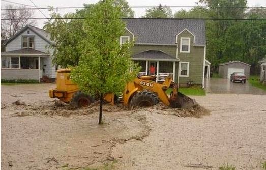
| The front pushing slowly across New York state and Ontario has been the focus for heavy rain since Monday. The picture above shows major flooding in Gowanda in western New York. (Gowanda Volunteer Fire Dept.) |
Friday 16 May 2014
Heavy rain tonight for Montreal - cooler weekend
Dark clouds are on the western horizon as a very slow moving cold front inches its way across Ontario towards metro Montreal. This front has been the focus for heavy rain along with some isolated thunderstorms. A conveyor belt of moisture stretches from Cuba to Ontario.Yesterday was a windy and warm day in southern Quebec with 29C (85F) at Trudeau Airport. As expected other areas were even warmer with St. Anicet at 32.9C (92F) and Cornwall/Massena NY at 33C (92F).
The aforementioned front will take the next 24 to 36 hours to clear Montreal with rain at times heavy forecast to start this afternoon and only taper off Saturday. Environment Canada has posted a heavy rainfall warning for most of southern Quebec including metro Montreal for 40-70mm of rain (approx 1-3 inches). The ground remains saturated from recent snow melt so runoff could be fast with some flooding possible. Skies will turn partly cloudy by late Saturday and clouds and sun will mix for the balance of the long holiday weekend. It will be much cooler behind the front with temperatures only in the teens. The cool air behind the front was evident this morning in Toronto. Montreal was a warm 22C (72F) at 7am while Toronto was 9C (48F). While portions of eastern Ontario were close to 32C on Thursday Toronto was only 19C. Behind the front very cold air is settling in with frost and freeze warnings in the upper Midwest and even snow in northwest Ontario.
Subscribe to:
Post Comments (Atom)
No comments:
Post a Comment