 |
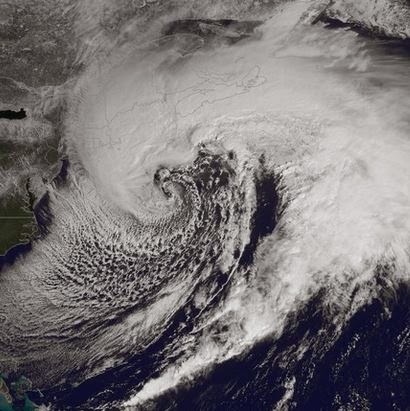
| NOAA image of the "white hurricane" pounding Atlantic Canada. Montreal remained on the far western edge of the cloud shield with gusty north winds yesterday. |
It basically was a white hurricane that pounded Atlantic Canada on Wednesday. Reports of 25-50cm of snow being blown around by winds either side of 100km/h all day and at times as high as 170km/h. Grand Etang on Cape Breton Island had a wind gust to 171km/h (106 mph). This remarkable storm wound up like a spinning top quickly with a central pressure all the way down to 955mb. For a time it was the strongest storm anywhere on the planet. This morning the precipitation has moves into the coastal waters as well as Newfoundland, but winds remain gusty with several reports to 90 and 100km/h. The Trans Canada Highway between New Brunswick and Nova Scotia was closed for most of the last 24 hours but has since opened. Visibility was near zero for most of the period but has started to improve very slowly. Prince Edward Island remains closed with roads blocked by 53cm of snow. The Confederate Bridge is still shut down. Most Island roads are impassable and all flights have been cancelled. Schools and businesses are shut for a second day. Power outages are widespread across the region with utilities working in less than ideal conditions to restore electricity. Newfoundland Power has warned that is could take several days to bring all customers back onto the grid.
 |
| All travel including Halifax public transit ground to a halt in the afternoon in dangerous weather with zero visibility. (Radio Canada) |
MONTREAL WEATHER
The silver lining from all this is that warmer air is on the horizon for most of eastern Canada. It will not be tropical but high temperatures will nudge above 0C on Friday and into the middle single digits to perhaps 10C (50F) over the weekend form Ontario east into storm weary Atlantic Canada. After the cold this morning, -14C currently, we will have a high of -2C. Montreal will have a period of rain and snow mixed beginning this afternoon and persisting into Friday with perhaps 2-5cm. The weekend at this time looks dry for southern Quebec and mild between 7 and 9C (45-50F). There is another much weaker coastal system expected to move northeast on Sunday that could bring more snow or rain to portions of eastern Quebec, at this time passing to far east to affect Montreal.
No comments:
Post a Comment