Pages

Friday 28 February 2014

Snow squalls and cold return to Quebec & Ontario

Carnage on the 400 series of Highways in Ontario. This wreck involving 100 cars was south of Barrie. (CTV)
Multiple snow squalls along a sharp arctic front caused a mess on Ontario roads during the morning commute on Thursday spreading into southern Quebec last evening. A wall of snow and wind pushed off Georgian Bay yesterday morning engulfing Highway 400 south of Barrie, creating zero visibility. Nearly 100 cars were involved in the quick wreck closing the highway for most of the day. Three people were taken to hospital while others were treated at the scene. Buses were brought in to protect drivers and passengers from the extreme cold that has returned to Quebec and Ontario. The front arrived in Montreal late last evening with a series of heavy squalls putting down a quick 2-5cm of snow from the South Shore and here on L'Ile Perrot across the Townships and down to the US border. Gusty winds and blinding snow made travel last night south of the city challenging for a few hours.

A spectacular shot of a snow squall advancing on the northern GTA on Thursday. As we always warn, you can really see how it can go from sunshine to a whiteout in seconds. (CTV)
This morning skies have cleared and it is just plain cold again. I have -19C (-2F) here on L'Ile Perrot and that seems to be a popular temperature around southern Quebec and eastern Ontario. The wind is making it feel like -29C (-20F). Windchill advisories are in place for portions of Ontario and New York but none here in Montreal. I guess we are just too tough for the cold now. Any way you look at it temperatures are cold, running about 10 to 15 degrees below the normal high/low for late February. It will be sunny today but only make it to -12C. Another weak clipper system and cold front will bring light snow to the region on Saturday into Sunday with perhaps 2-5cm. The main storm track will remain well to the south of southern Quebec over Pennsylvania. Temperatures will warm briefly on Saturday to -4C before a cool down Sunday.

Wednesday 26 February 2014

The 4th warmest January on record around the globe


There are just a couple of days left in February it what has been a relentless winter. While many have us have complained about the frigid cold, and with reason, it appears January was not so cold after all, at least globally. According to the National Climatic Data Centre, a branch of NOAA in the US, January was the 4th warmest on record globally dating back to 1880. The average temperature of land and sea was 12.7C or 0.65C above the 20 year average. Landmass areas were 1.17C above the long term average of 2.8C. The warmest places were where you would expect the coldest temperatures to be found, Greenland, Western Canada and Alaska. Portions of Brazil and South Africa also had record warmth. It also marked the 38th consecutive January and 347th consecutive month above the long term averages. Global Warming?Food for thought for sure.

Montreal for comparison had an average temperature of -10.2C for January compared to the normal of -9.7C. There were wild swings in the extremes which likely wore us all down including -27.3C for a low and plus 7.3C for a high. Not so good for roads, cars, pets and people. February has actually been consistently colder in Montreal so it will be interesting to see where the month ranks once we tally up the numbers.

This morning we are looking at a light dusting of snow across southern Quebec as an arctic front moves across the region. Strong winds behind the front will reach 30-50km/h and will cause some blowing snow issues on off island roads. Already this morning a major accident near Cobourg, Ontario on the 401 is being blamed on the snow. More squalls will lift off of Lake Ontario making travel in that area dangerous at times. The snow here will taper off with just a few flurries and cold with highs near -10C. Cold overnight lows of -16C tonight will be followed by more light snow Thursday, windy again at -10C. The weekend looks unsettled with light snow and continuing cold with lows near -20C in Montreal and as cold as -30C elsewhere in the province. It looks like it may warm to above the 0C mark by the end of next week. Keep in mind that March historically has had our biggest and most disruptive snowstorms. Time will tell if this year holds another for Montreal.

Tuesday 25 February 2014

Winter returns to southern Quebec & Ontario

Cold weather will dominate the forecast for the rest of this week and well into the next one as arctic high pressure drives frigid air south. Environment Canada has posted a special weather statement for the province indicating very cold air and windchill values for the balance of the week. Temperatures this morning are hovering around -15C in southern Quebec, but a decent west wind is making it feel as cold as the minus 20's. It will be a very cold week with temperatures running 5-10 degrees below normal. We can also expect clouds and a few flurries as weak disturbances move across the region. The first of these today will give some light snow this evening and especially early Wednesday. A few centimetres may fall locally. More light snow is forecast for Thursday with another couple of centimetres. Temperatures will remain cold with low near -20C and daytime highs at best -10C for Montreal. At this time no big storms are on the horizon.

Monday 24 February 2014

Much colder air this week in Montreal

It was a beautiful weekend in southern Quebec including the Bishop's University Campus in Lennoxville. 
The sunshine and mild temperatures began to slowly eat away at the piles of snow in the Townships. 
(Photo: Maggie Lowson)
It was a very mild weekend in southern Quebec with warm sunshine and high temperatures well above freezing in the plus 4 or 5C range. Lots of sunshine resulted in plenty of melting with the first all out assault on the snow pack in over a month. It was windy with gusts at Trudeau Airport up to 80km/h on Saturday, much lighter Sunday up to 50km/h. Today will be another breezy day out of the southwest up to 40km/h and much colder with high temperatures pretty much where they are currently, -7C. It is absolutely frigid on the Prairies for late February and some of that cold air will begin to filter into eastern Canada this week. This morning Regina is -34C, Saskatoon -31C and Edmonton -27C.

It will get progressively colder each day this week in Montreal with a continued threat for light snow showers or flurries. No big accumulations are expected with the best chance of measurable snow on Wednesday morning when an arctic boundary crosses the St. Lawrence Valley. There could be a brief snow squall, I will get a better estimate of the timing as we get closer. In the meantime temperatures will range from -7C for highs to -12C for lows. Once we get into the colder air by Wednesday, lows will drop into the -20's through the end of the week with cold daytime highs in the high minus teens.

Friday 21 February 2014

Rainy & windy Friday - much colder next week

This same storm that is giving Montreal rain is producing big thunderstorms up and down the east coast. This spectacular shot via Twitter was taken in downtown Nashville Thursday afternoon.
Freezing rain warnings remain posted for the entire area, however it has warmed above freezing south of the St. Lawrence River, so they should expire in those areas soon. Low pressure this morning is over Wisconsin with a very long warm front to the east across Ontario and New York State. The front will attempt to lift north of Montreal this morning. Precipitation has overspread the area in the form of freezing rain or rain. I am showing rain here on L'Ile Perrot at 1C (33F) so I think icing will be limited. However as I have mentioned, the ground remains cold so ice can be hiding under any puddle! It will be a mild and windy day with plenty of rain around, up to 25mm (1 inch) possible, high 5C (41F). Winds will increase as well today from 50-80km/h out of the southwest by afternoon. The rain will taper to a few flurries tonight as a cold front crosses the region. There may be a few heavier showers along the front and still the possibility of a rumble of thunder. Thunder was reported in Toronto late last night along the warm front.

Saturday will be another windy, mild day as the storm system stalls across central Quebec. Montreal will have one more warm day before another cold snap starts by Sunday. The high Saturday will be 4C but only -3C on Sunday. Next week looks very cold with highs in the -6 to -10C range and very cold overnight lows down to -18C.

This system has had widespread impacts with cold snowy weather across northwest Ontario and the upper Midwest, and severe thunderstorms with tornadoes across the Ohio Valley southward to the Gulf Coast.

Thursday 20 February 2014

Freezing rain warning for Montreal

A major storm is taking shape over the central US plains today and is expected to lift northward towards the central Great Lakes. After a sunny, mild day here in Montreal clouds will be on the increase this evening. Expect precipitation in the form of a mix of snow and freezing rain to begin after about 8pm this evening and continue overnight. I believe we will see a quick change to plain rain here in Montreal and points south to the US border and beyond. However north and east of Montreal as well as in the Ottawa Valley the freezing rain may last into the Friday morning commute. There will be lots of water and ice around on Friday morning so allow yourself extra time. Total precipitation will be significant with this storm with between 25-50mm (1-2 inches) expected across southern Ontario, southwest Quebec and northern New England. For this reason Environment Canada has posted a freezing rain warning for Montreal and the Ottawa Valley, with heavy rainfall warnings posted for southern and eastern Ontario. Temperatures will rise to 4C today and drop just below freezing to -1C tonight in Montreal. It will be 4C on Friday in the rain. By late Friday afternoon a very strong cold front will sweep the region with a few heavier showers and perhaps a rumble of thunder. Winds will be gusty on Friday out of the southwest up to 70km/h possible ahead of the cold front.

My concern as always with an elongated warm front, is just how quickly we can dislodge the cold air at the surface of the St. Lawrence Valley. I believe it will be fast this time with a quick transition over to plain rain, but you just never know, each front behaves so differently once it interacts with the valley. Keep in mind that we have a very cold surface and even when the temperatures go above freezing there will still be lots of ice around under the puddles.

Wednesday 19 February 2014

Welcome to The Suburban Weather Blog

I want to welcome some of my new readers to the Valley Weather Blog via The Suburban website. I have been writing about the weather since I was about 10 years old, oh so long ago. This blog has been around since 2005. I bring to you a clean, uncomplicated view of the weather for Montreal, southern Quebec and many other parts of North America. Thank you for the read, enjoy and please send in any comments or weather photos you may have and I will share them with our readers.

Another storm system will impact the St. Lawrence Valley and southern Quebec late Thursday into Friday. Until then we are looking at much milder air in place today with perhaps our first high temperature above freezing in Montreal since January 18. There will be some wet snow today, not much accumulations, perhaps 1-2cm with a high of 1C (34F). On Thursday weak high pressure will be in place with partial sunshine before the clouds thicken by late in the day. Temperatures will again be mild with a high of 2C (36F) overnight lows below freezing to -3C (27F).

Another winter storm just missed Montreal on Tuesday with only 1-3cm of snow here. The storm pounded southern New England and Atlantic Canada again with as much as 30cm of snow. Above is Portsmouth, New Hampshire yesterday. Photo: Seacoast Online
Tomorrow night Montreal will begin to be influenced by strong low pressure that is forecast to develop over Colorado and move towards the central Great Lakes. A long warm front will approach Montreal with snow and freezing rain developing in the evening and lasting into the overnight from Montreal south and well into Friday north and east of the city. The wintry precipitation should change over to rain for most of us in southern Ontario and Quebec but areas north of the St. Lawrence Valley could see a prolonged period of freezing rain. Travel early Friday may be impacted. We are expecting 25mm of precipitation in various forms. I will try to nail down the amount and exact timing as the event draw closer. It will be mild on Friday with a high of 4C (39F). A strong cold front will sweep the area late on Friday with very strong and gusty winds and some isolated heavy rain showers. There may even be some thunder late Friday. This storm will become another big news-maker as the cold front produces some severe thunderstorms from the Ohio Valley into the deep southern US Thursday and Friday.

Tuesday 18 February 2014

Snow followed by a much needed thaw for Montreal

Thunderstorms by late Thursday and Friday could stretch from Ontario to the Gulf Coast just days after heavy snow. The winter of 2013-2014 certainly has been anything but boring.
It is a windy and chilly morning in Montreal as low pressure and an associated warm front move south of the city. Gusty winds have developed along with some snow. I expect around 2-5cm for Montreal in the next few hours. There will also be some blowing snow as northeast winds gust to 40km/h. Before the cloud cover moved in last evening we managed another frigid night with the temperature hitting -20C just after midnight here on L'Ile Perrot. From that point it has slowly risen and that trend will continue today. Look for a high temperature near -3C today and up above freezing to plus 1 or 2C Wednesday. More flurries and perhaps some freezing drizzle overnight into Wednesday as the warm front lifts north of the city. By Friday we will be in the mild air with showers and temperatures up to 4C. The weekend at this time looks cooler as a potent cold front sweeps the region late in the day Friday. That front is expected to produce a round of thunderstorms believe it or not from the Gulf Coast to the Great Lakes. Perhaps we may hear a rumble of thunder in Montreal as well in what has been an odd winter. I will have more details on that later.

Monday 17 February 2014

Warmer weather on the horizon for Montreal

Clearing away the 30cm of snow at the Champlain Centre in Plattsburgh, NY on Saturday. The Valentines Day storm has cut deeper into exhausted snow removal budgets. The winter of 2013-2014 is proving costly for many parts of Canada and the US in the form of thousands of flight cancellations, power outages, heating costs and loss of income. (ValleyWX Photo)
It is another cold morning here in Montreal, currently -17C (2F) at my home, but there is some good news on the horizon. We are finally seeing hints of a pattern change after what has been one long and cold winter. Officially Montreal has not gone above 0C (32F) in the month of February. As we all know, with the exception of one week in January, most of this winter has been spent well below freezing. That is about to change this week as a warmer southwest flow of air begins to make its mark as early as this evening. After a sunny and cold day today at -10C (14F), temperatures will only drop to -14C (7F) tonight and moderate to near freezing on Tuesday. A little light snow is possible as a system slides to our south on Tuesday with accumulations of 2-5cm possible across the area including eastern Ontario. By Wednesday the warmer air will be well established with highs near plus 3C (39F) and a few showers or flurries. It will remain mild well into the weekend with sunshine Thursday followed by more showers on Friday.

Over the weekend another storm developed and passed well south and east of Montreal, this time sparring southern Quebec with just a few flurries and gusty winds. It rapidly deepened into a major blizzard affecting the New England Coast and Eastern Canada. Parts of New Brunswick and P.E.I. reported between 30 to 40cm of snow with winds gusting over 80km/h. In Newfoundland snow and freezing rain were accompanied by fierce winds, a peak gust of 170km/h was reported at Wreckhouse, with 124km/h at Cape Race.

Friday 14 February 2014

20-40cm snowstorm for Southern Quebec

Heavy snowfall on L'Ile Perrot Friday morning. (ValleyWX Photo)
So what looked to be a near miss two days ago will turn into a 25cm Valentines Day snowstorm for Montreal. You have to love weather forecasting in southern Quebec. As with any coastal storm, a track change of 50km east or west can spell a huge difference in what you see at the surface. We are seeing that this morning with a sharp cutoff in snow as you move northwest of Montreal into the Ottawa Valley. Here on L'Ile Perrot I have measured 15cm (6") since midnight including 5cm (2") between 4am and 6:30am. Overnight we had strong northeast winds up to 65km/h they have since backed off to the northwest and down to 30km/h. They will gust to 50km/h today causing blowing snow with visibility often under 1km. The heavy snow will taper off by noon with storm totals of 15cm for eastern Ontario, up to 25cm here in Montreal and 30-50cm in the Townships, Quebec City and the Gaspe region. The snow has produced the usual problems on the roads in southern Quebec along with a fair amount of school closings, oddly north of the city where they have had less snow. There are numerous delays and cancellations at Trudeau Airport with their website advising you to call ahead.

Strong low pressure on the Maine coast this morning is spiraling precipitation down the St. Lawrence Valley. The barometric pressure has been falling rapidly for the last several hours indicating a deepening storm, it is currently 990mb here at my home. Temperatures are thankfully mild at -3C, where they should remain for most of the day. It looks like another weak system will bring 2 or 3cm of snow for Saturday before we clear out for a calm and cold Sunday.

Thursday 13 February 2014

Storm has started in Montreal

Sat image of major Nor'Easter located east of Atlantic City Thursday evening. Snow has fallen from Georgia to Atlantic Canada including Montreal.
Strong low pressure is located off the Jersey Shore near Atlantic City this evening. The system is forecast to deepen rapidly as it lifts towards Cape Cod and then off into Atlantic Canada. Heavy snow has been falling across portions of the middle Atlantic states into New England today. As much as 60cm (2 feet) has fallen in some Virginia and Maryland locations. The steady snow is moving into Montreal as of 8pm with 10-15cm forecast by morning. A snowfall warning has been posted for Montreal and most of southern Quebec. Winds are increasing out of the northeast and will gust between 40-60km/h overnight in Montreal, and up to 100km/h in Quebec City. Widespread blowing snow is forecast along the entire St. Lawrence Valley of Quebec with travel not recommended south and east of Montreal. As much as 50cm may fall in Sherbrooke and the Townships into northern Vermont before the snow tapers off later Friday.

A more westerly track equals snow for Montreal

SNOWFALL WARNING POSTED FOR METRO MONTREAL @ 11:30AM

SNOW AMOUNTS FORECAST:
Quebec City - Townships - Burlington - Plattsburgh 15-30cm (6-12")
Vaudreuil - South Shore 10-15cm (4-6")
Montreal 15cm (6")
Cornwall 5-10cm (2-4")
Kemptville 2-5cm (1-2")

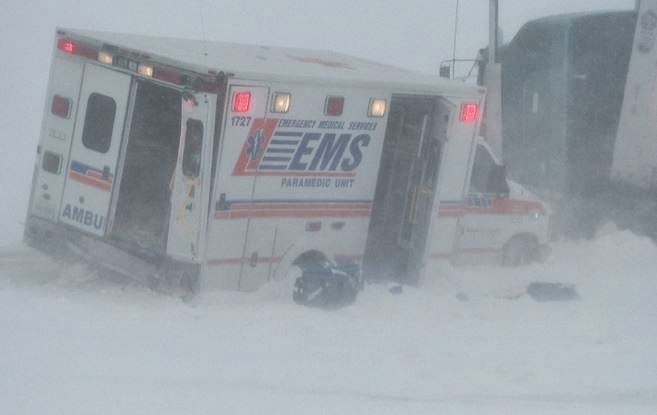
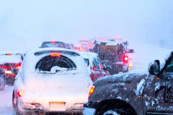
This has been one harsh winter in so many places. The photo above from Global News Regina is a major accident involving 6 vehicles (including the Ambulance) on the Trans Canada Highway near Pense, Saskatchewan. The road was closed between Moose Jaw and Regina for hours Wednesday. 
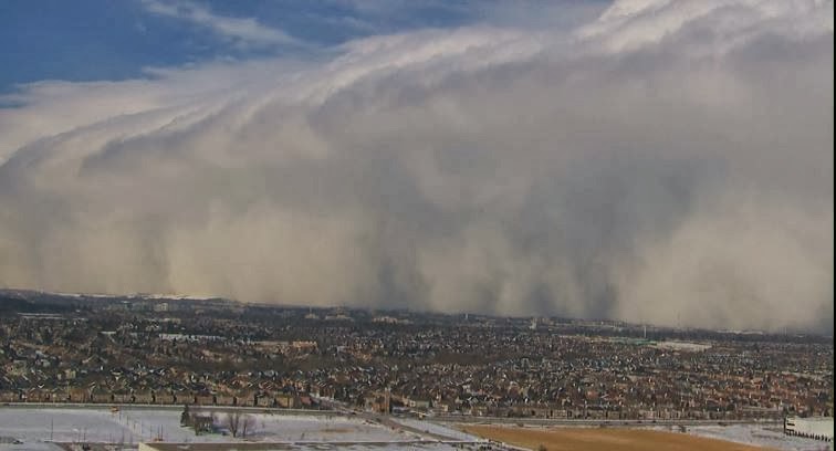
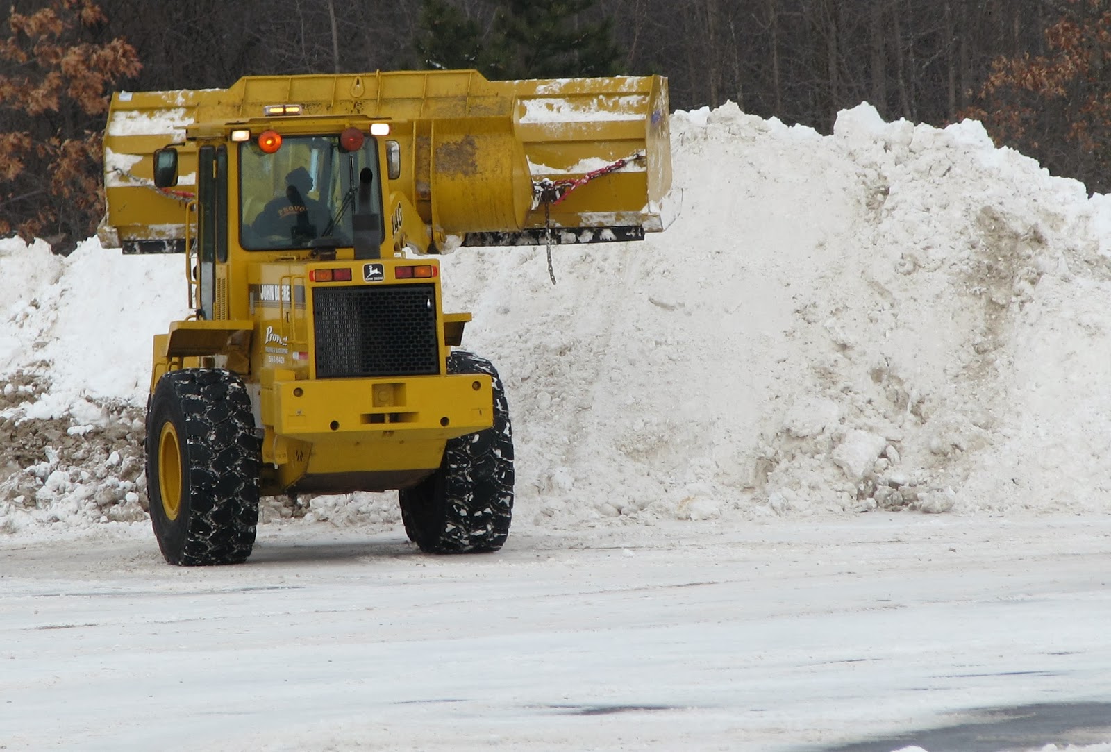
Winter storm warnings are in effect for Quebec City and the Eastern Townships as well as all of Vermont and eastern New York. The much advertised winter storm (at least on this Blog) will arrive later today and into the overnight hours. Strong low pressure that has given the southern US a major ice and snow storm will lift from Cape Hatteras northeast to Cape Cod overnight and into Atlantic Canada on Friday. Clouds will increase in Montreal today along with a strengthening northeast wind. The snow starts this evening and will last until about noon on Friday. There will be a sharp cutoff in amounts as you head north and west but look for a good 5-10cm for metro Montreal with as much as 15cm across the South Shore and up to 30cm in the Townships and Quebec City. While no warnings are in effect for Montreal at this time, strong winds, up to 60km/h will cause considerable blowing and drifting snow on off island highways. Further east the heavy snow will be accompanied by winds up to 100km/h around Quebec City. I would advise not to travel south or east tonight and Friday.

Eastern Ontario has a special weather statement in place for snow and wind overnight with about 5cm possible. Travel down the 401 towards Cornwall and Prescott will be tricky but once west of the 416, it should be much better. Temperatures are cold again this morning at -20C here on L'Ile Perrot. Look for highs around -10C today warming overnight tonight to -4C or so in the snow by Friday.

The weather has been nasty in so many places. Yesterday this same storm created traffic gridlock on many North Carolina Highways including Raleigh and Charlotte and virtually shut down Atlanta. Ice covered trees and power lines came crashing down across Georgia, Tennessee and the Carolinas with hundreds of thousands in the dark.

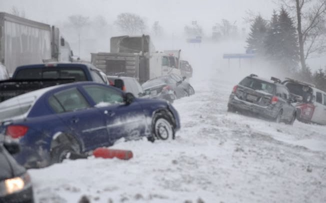
Meanwhile snow and blowing snow from a clipper system out west created dangerous travel across the southern Prairies with roads closed in Saskatchewan and numerous major accidents with injuries.